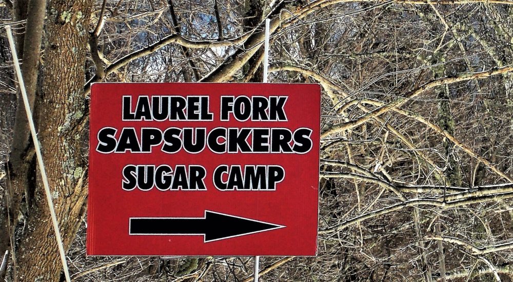
Highland’s Laurel Fork Sapsuckers On Top of the World

Originally posted in March 2014….
Okay, these guys get the prize for best view … and that’s saying a lot in Highland County where it’s impossible to find a bad view. Located on top of Alleghany Mountain that straddles the Virginia-West Virginia line ten miles west of Monterey, Laurel Fork Sapsuckers has the highest elevation of the seven sugar camps. How high? Try 4,400 feet. The breath-takingly spectacular scenery alone is worth the drive. They are also the newest camp. The land has been in the family for four generations but the camp has been operating since 2010 and features eighteen acres of sugar maples. This was our first visit but it won’t be our last.
Earlier in the day we had been to Duff’s Sugar House south of Monterey so when we left we took Rt. 84 from Duff’s to Rt. 600 at Back Creek and followed it north to Rt. 250, a drive we’ve done many times in the past. The pavement turns to gravel as this scenic back road climbs the ridge that parallels the Back Creek valley, and it was muddy and soft in many places but frozen over with ice in others. When we emerged onto Rt. 250, it was only a few miles further west to Laurel Fork Sapsuckers Sugar Camp. Why not, we thought … let’s go!
First thought when we turned at the very unassuming looking yard sign that said “Laurel Fork Sapsuckers:” Top of the world. Second thought: Oh my gosh, there’s so much mud. The sun was shining, snow was melting, and the parking area just off Rt. 250 was soft as we backed into a grassy-muddy spot.
A young man was standing nearby, dressed for the cooler-than-Monterey weather at that high elevation, and he walked toward us as we tried to get our bearings. Where was the sugar house? Where were the people? All I saw were a couple of parked cars, what looked to be an abandoned house, and mountains as far as the eye could see.

The young man was named Ladd and he pointed toward the road that continued up the mountain beyond the parking lot and disappeared into the snowy woods. That’s where everything was located, he told us. The road was bordered by deep snow which made it a gully that had a river of water running downhill.
“You need four-wheel drive to get up there,” he told us. Hmm … our four-wheel drive had moved away when our daughter married.
Ladd smiled, his rosy outside-in-the-cold cheeks glowing in the sun, and said, “I can take you up,” and pointed to a (gasoline engine) mule. I asked how far. “About half a mile,” he answered. He pointed to the seat.
Mules are generally two-passenger vehicles — driver and guest — with a cargo area in the back, and his was loaded with something back there. Patting the seat where there was a hump between the two sides of the seat, he smiled and said, “One can sit here.” On the hump, he meant, in order to get three of us on the two-passenger seat.
I looked dubiously at the muddy river, er, road that led to the sugar camp, looked back at our car, and then my eyes wandered out again at the breath-taking scenery that looked east into Virginia and west into West Virginia. That was it … I was smitten. My curiosity was piqued as to how much higher up this mountain he would take us and what, exactly, was there. I’ve never met a back road I didn’t want to explore so grabbed my camera and extra batteries from the car, put on my coat, and loaded into the mule with my husband and Ladd. And off we went on a bumpy, adventurous drive in the cold mountain air that had us all laughing. It was exhilarating.


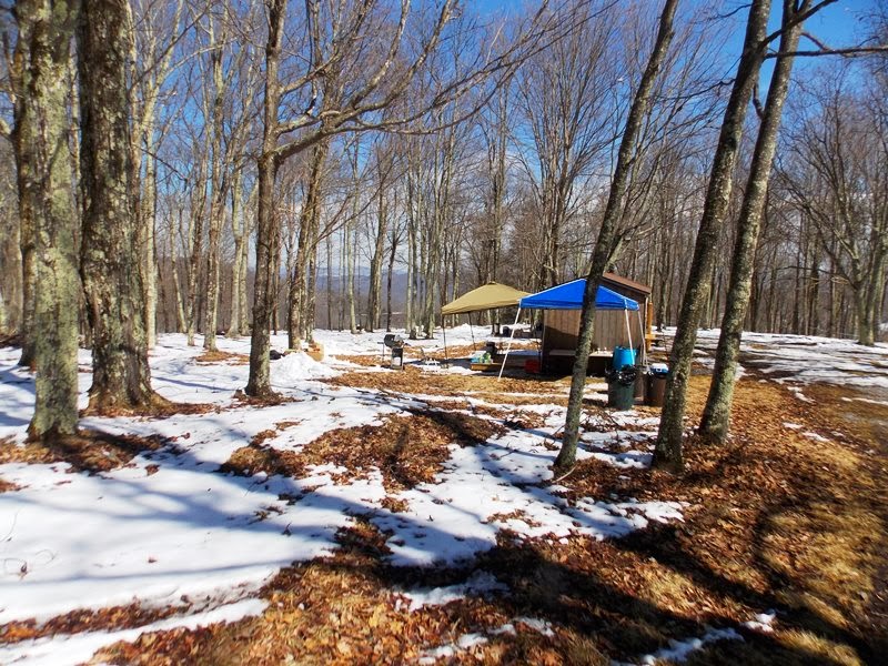
We finally pulled into a parking area where Ladd — that’s when I shook his hand, asked his name, and thanked him for the ride up the mountain — dropped us off to … what? There were a couple of tarps set up beside a wooden building, and some tables in the snow with people sitting around eating lunch and snacks. Trying to figure out what was where and looking for a sign to point the way, I started following the path toward the building. It was like looking for signs of civilization to ask directions. Where was the sugar house? We were basically in the woods on top of one of the tallest mountains in Virginia. It looked like a winter wonderland and, quite frankly, felt as if we could have been in Vermont where maple trees also are a thriving business. It was exactly the kind of out-of-the-way place I like to explore.


“We’re heading down to the bottom,” he said. “You’re welcome to ride.”
As I hesitated, a young couple who had been walking behind us overheard and the young lady said, “I’ll take a ride!” Sam, looking out the window, called out, “Hop on in,” and those two twenty-somethings nimbly hopped over the tailgate and into the bed of the truck. Sam looked questioningly at us and, after a quick mental assessment, we said, “We’ll ride, too.” So up and over the tailgate, not quite so nimbly, to where the young lady was sitting on the side so I sat beside her and Mr. Mitchell perched beside the young man on the other side, and off we went.
Woo-hoo, adventures galore! As the brisk air whisked our hair and the road jostled us back and forth, we talked to the young couple on the way down … they were new to Monterey … what do you do that you can live in Monterey, I asked … he’s into computer technology. Ahh, they can be just about anywhere. I would love to have spent more time getting to know them since they were new to the area but we arrived at the parking area and Sam stopped to let us all climb out. I shook Sam’s hand and thanked him, and then we said goodbye to the young twenty-something couple whose vehicle, coincidentally, was parked beside ours. As Mr. Mitchell and I pulled off our muddy boots for the ride to Monterey, we were grateful for the friendly faces we had met that day.

If you visit, I hope you get to meet up with Ladd, the friendly Sapsucker ambassador, and take a ride on his mule. To keep up with activities, join their Facebook page. For more information about Laurel Fork Sapsuckers, see Faces of Farmers.
Other posts and photos from Highland Maple Festivals:
– 2017 Mountains, Maple Syrup, Sheep … Highland Maple Festival
– 2014 Maple Festival … Laurel Fork Sapsuckers at the roof of Highland County
– 2014 Highland Maple Festival begins this weekend
– 2014 Highland Maple Festival … lunch at Evelyn’s Pantry in Monterey
– 2013 Maple Festival at Duff’s Sugar House – first weekend
– 2013 Maple Festival at Duff’s – second weekend
– 2012 Highland Maple Festival
– 2011 Maple Festival at Duff’s Sugar House
– 2011 Maple Festival – Walk of Honor to thank U.S. veterans
– 2011 – 53rd annual Maple Festival
– 2008 Highland Maple Festival … almost heaven
Photos by Lynn R. Mitchell
March 8, 2014
